Monday, April 13, 2015

04-13-2015 - BAHAMAS, Marsh Harbor, 4-9-15 – 4-13-15

Marsh Harbor is the third largest town in the Bahamas, after Nassau and Freeport. It’s not a Cay (island, pronounced “key”). It’s on the mainland, Great Abaco Island, a big island, which also includes Treasure Cay (a town, not really a Cay) and a few other places. Marsh Harbor is the place to go to get things fixed, and to get groceries, for a good selection and better prices.  A lot of cruisers spend a considerable amount of time here in the well protected harbor, and do short trips to other Cays that are close by.
On the way to Marsh Harbor

On the way to Marsh Harbor
Friends
We arrived here on Thursday afternoon, April 9. The first boat we saw in the anchorage was that of our friends, Helen and Stan, on s/v Voyager. We were hoping to see them, and they were happy to see us. We had met them in Vero Beach and we had a lot of fun together. They decided to leave in February to cross over to the Bahamas with other friends, Joan and Tim, on s/v Head over Keels. Since they arrived at West End, Helen and Stan began to have trouble with Voyager’s diesel engine, which had now reached a very serious and unfortunate stage. Stan is a very competent and confident sailor, so they made their way across the Little Bahama Bank to Green Turtle Cay, through the “Whale” and then to Marsh Harbor, with sails alone and no auxiliary engine except the one in their dinghy, which they used to maneuver the boat in close quarters. They were waiting for parts, so that “Basil” (aka “Bah”), the local mechanic, could rebuild their engine before he was to leave for vacation on May 1. Parts might get here just in time. Meanwhile, they were stuck in Marsh Harbor.

Dinner with Helen and Stan, on Summer Wind
Cruiser’s Net
Marsh Harbor is where we started listening each morning to the “Cruiser’s Net”, a structured informal program from nearby Hope Town that airs over the VHF radio, channel 68, at 8:15 AM. The program begins with a weather forecast recap, then reports on all of the nearby ocean passages (the Whale and 3 or 4 others), followed by advertisements of services (“Yoga class this morning in Hope Town”) and restaurant specials. Then there are the announcements – which is a free-for-all of requests for info or assistance (“Does anyone have any 2 part epoxy for fixing a hypalon dinghy?”, “What is the racing schedule today?”, “Does anyone know who can fix a Westerbeke generator that is overheating?” “We have visiting Canadians, does anyone know the hockey score from last night?). Sometimes this also includes stolen or missing boats, or people searching for people. The next section of the program allows cruisers to introduce themselves as newly arrived or leaving. We announced on Saturday that we arrived on Thursday, someone else announced their arrival and plan to stay for a few months, while someone else announced that they were leaving. The Cruiser’s Net program can be heard in other areas, but some of the conversations cannot be heard because of the distance. Sometimes they are relayed. Mostly it’s restricted to Elbow Key (Hope Town), Marsh Harbor, Man-O-War Cay, and any smaller Cays that are very close by.

Town 
There is one traffic light in Marsh Harbor. Traffic is very frightening and confusing to us, because they drive on the left side of the road here. We have to look both ways, several times, before crossing the street. We are accustomed to looking again to the left just before crossing. Here we have to remember to look right last! There are a lot of cars. And here they drive full sized cars, whereas in Green Turtle Cay it was mostly golf carts. Many streets have no sidewalks, most have no shade and it’s dusty. Town is sort of depressing to me. A lot of the storefronts are empty. There is no center, no order. It’s hard to find anything we expect, even though there is a lot here.
The one traffic light, at Marsh Harbor 
(Note: these cars are not parked, they are driving on the left!)
Phone service
There is an odd arrangement of businesses here in Marsh Harbor. My HTC cell phone had stopped working and could not be charged or turned on, and we had no service with Verizon, so our first stop was the Batelco (Bahamas Telephone Company) store, to see if they could help with my phone or with providing service.  The Batelco store had a security guard who opened the door, an unseen cashier off to the right side, a small display of phones in the middle, and “Customer Service” on the left, with a waiting room that held about a dozen chairs. The message was clear, “Be prepared to wait.” Two people were ahead of us. Eventually a woman (Not Customer Service, Security or Cashier) came over to see what we were looking for. If our phones were not locked, they could give us service. She looked at each of our phones, and removed the batteries to check the sim cards. No conclusion. They don’t fix phones, for that we have to go across the street, walk past the car wash to the ”All Mart”. So if we could get mine working, we’d be able to see if it’s locked or not, and if it’s not, we can get service from Batelco. Chuck’s did not have a removable Sim card, so no Batelco for him.

We walked down the street to the All Mart, which was also a pawn shop. The door was locked. We rang the bell and we were buzzed in. The person who can fix phones, Wayne, was away in Nassau, expected back the next day. Moses, the very helpful and bright young Bahamian-and-American guy who was working at the counter, was able to charge my battery externally, overnight, with a device that they sell. My problem could be the phone’s charger, or any of several other parts. They do all of the repairs for the Batelco phones. Batelco only sells them, they don’t fix them. He said if they did, he’d be out of business.

We came back the next day to see Wayne, who was still not back from Nassau. Ryan, Moses’s counterpart, checked the phone with the charged up battery and said it was a software problem. Wayne doesn’t do software. We’d have to go further down the street, to another business, Epyon Technologies.

We found Epyon, and the door was locked but the outer security door was still open. We rang the buzzer, nothing. Too late in the day, on a Friday afternoon? Rang it again and we were buzzed in. A pretty young woman with very strange hair – white in front and dark brown everywhere else – who knew a LOT about phones helped us. She and her husband run the business and write software for phones and anything else. If my phone were working I would have taken photos of her, and of the shop, with its interior door (to the room that contained her very tall husband) covered with circuitry. She tried the recovery process on my phone and proclaimed it DEAD. We asked why Chuck’s seemed to be stuck on 1980 all of a sudden, and she said that was because the Batelco lady removed his battery. “She should know not to do that with these phones!” His is CDMA, the towers here no longer use that. He might be able to reset it in Hope Town, they have CDMA there. She said Apple phones reset to a different date, December 31, 1969.

We went back to Batelco to see if we could buy a local phone that we could use as a hotspot. The guard was letting someone out, and she said they were closed. It was 5:15 and the door said they close at 4:30. So I guess it’s like some restaurants, where you can enter before closing and get served, regardless of how long it takes.

Maxwell’s Supermarket
So we continued on, and walked to Maxwell’s Supermarket, the big grocery store. They had a terrific assortment of fresh fruits and vegetables, all at ferociously high prices. We hadn’t planned on shopping, but we picked up some bananas, eggs, sausage for our friend, 2 limes and a small piece of blue cheese, $17.40. This includes 7.5% tax on everything.

The next day, we returned for a few more things, chicken and lamb, and some fruits and vegetables, $70, which again included the 7.5% VAT tax on everything.

We did not get any of the cereal for $8-10 per box, or beef for $10 per pound. I was tempted to get some goat and try to cook it, but it was over $8 per pound, so I decided against that experiment.

Harbor – no swimming
There is no swimming in this harbor. Chuck and I like to swim everywhere we go, unless we are specifically told not to. Maybe it’s allowed, the local kids do it. But one of our cruising guide books advised against it. One of the locals described it as “muddy”.  The real reason is there is no pumpout here, and we hear that boats just dump their holding tanks in the harbor. Unfortunately, I think I’ve seen some evidence of that floating by. We did not swim there.

Mermaid Reef – or not
Because we can’t swim in the harbor, and it’s really hot and we’d really like to swim, we took the dinghy around to the outside of the harbor, to Mermaid Reef in the Sea of Abaco. Mermaid Reef is a man-made reef, with small moorings for dinghies. We stopped at the first place that looked like a beach. We didn’t see any moorings, so we landed the dinghy on the beach, put on our masks and fins and entered the water. A very kind man called out to us from a nearby house. He pointed out an eagle ray in the water. I saw it, it started to come toward me, I backed away, and it left before Chuck could see it. Chuck had a similar experience with a barracuda. We both saw sea cucumber and various small and tiny fish. I collected a few shells, nothing special. Chuck played with his underwater video camera. We never saw a reef.

Picnic at Mermaid Beach
The next day, we decided to go to land, see the southern portion of the harbor, and find a place for a picnic. After a very long and hot uphill walk, we found Mermaid Beach, complete with snorkelers and tiny dinghy moorings. The sky was strangely dark over the water. It might be rain, or it might be because of some brush fires in the distance. We had our lunch and decided to return to the reef another time, by water, in the dinghy.
Mermaid Beach
Swimmers at Mermaid Beach
Mermaid Reef, from land, with signs of impending rain storm

On the way back, we wanted to stop for ice cream, but we wanted to sit inside, in air conditioning. We stopped at one place that looked like it might have ice cream, but Chuck didn’t want to stay because it didn’t have AC. It did, however, have the white and dark brown haired phone-fixing girl from Epyon & her very tall husband, as well as the sweets shop girl from Green Turtle Cay, “Momo,” who has equally strange very long hair that is bright red in front. They seemed to be together, with a few kids, so maybe the two girls are sisters. (I think they each mentioned that they are originally from Nassau.) There is a very small population here, and everyone seems to know everyone else. We saw other people we knew from Green Turtle while we were in Maxwell’s. They come over by ferry, visit family, and shop over here.

Unfortunately the next ice cream place was closed, and then we heard thunder. So we got our exercise for the day, making a run for the dinghy dock, after our very long, very hot walk, with heavy backpacks. Whew!

Rain laundry fail
We heard a few more thunder booms, but no rain yet. We got back to the boat and closed the overhead ports in time. I scrambled to do “rain laundry.” I grabbed all of my essentials (= underwear) and tossed them in some fresh water with Woolite. Then I wrung out each piece and hung it on the lifelines, so the rain could rinse it. I also put out a large plastic bin to catch (and measure) the rainfall.  Unfortunately, there was only a little rain. So I now have dry, soapy clothes. I added some of our precious tank water to the plastic bin to rinse the clothes, and hung them out the next day to dry.

Dinghy racing in the harbor
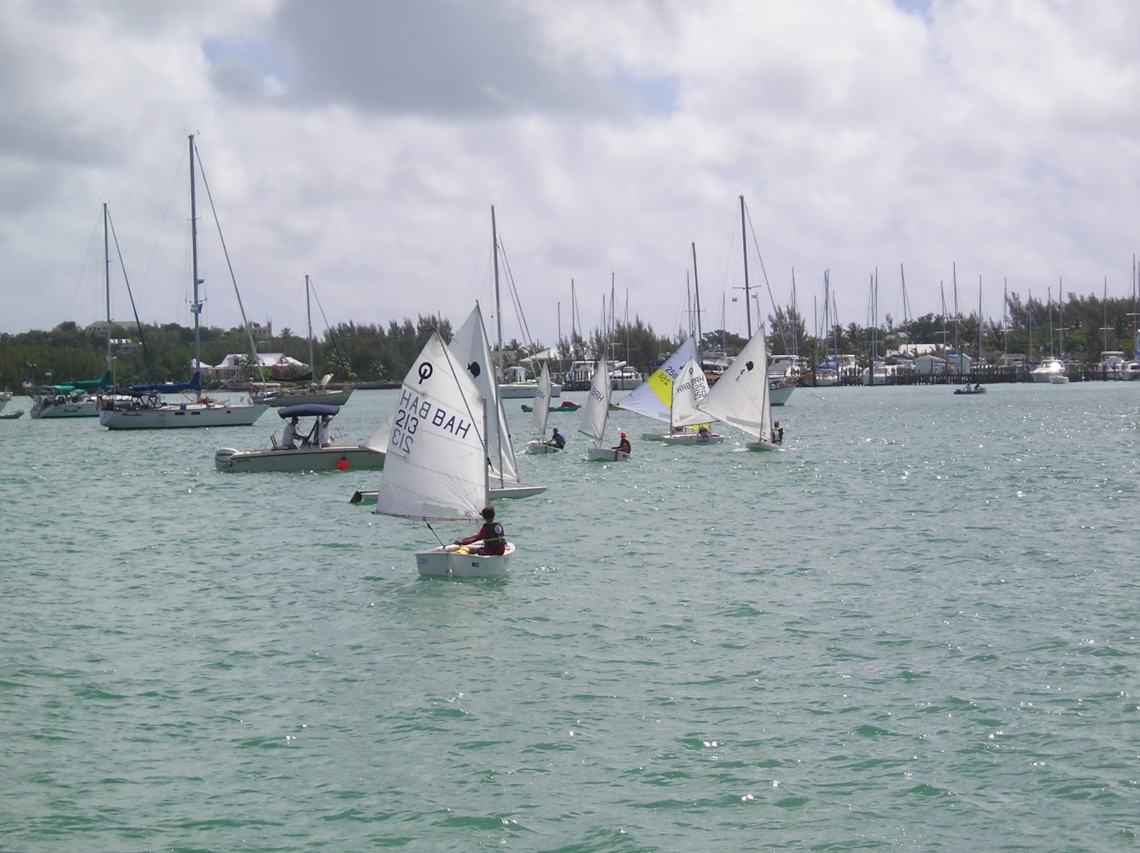
Dinghy races in Marsh Harbor
On Saturday morning there were dinghy races in the harbor – opti’s for the little kids and sunfishes for the adults. We were anchored just on the edge of the race course so we had a good view. Other small spectator boats with family members and pets were also floating around and inside the race course. This went on for quite a while and provided some good photo ops, now that I managed to resurrect my 11 year old digital camera, after replacing the batteries.
Dinghy races in Marsh Harbor
Sandy, watching the Dinghy races in Marsh Harbor
Dinghy races in Marsh Harbor

Electronics
Salt air is not good for electronics. My phone was dead and Chuck’s was acting up. My handheld radio, our “2nd backup” stopped working. We left batteries in it too long and they leaked a little. There is another small business that might be able to fix it, the person who fixes things is away in Nassau and expected back on Monday. We’ll see... Marsh Harbor seems to be a good place to get things fixed.

Leaving Marsh Harbor
The weekend evenings were very noisy, with loud music playing from the bars until late at night.

On Sunday we returned by dinghy to Mermaid Reef with our friends, Helen and Stan. We snorkeled above the manmade reef and saw lots of tiny and little fish. (Sorry, the UW camera was on the wrong setting, so no decent pictures.) Then we went out to dinner together at one of the local restaurants.

We stayed through Monday, 4/13/15, to revisit the electronics store. The fixing person didn’t come back from Nassau. The girl at the desk advised us to try the marine store across the street. We did. He didn’t fix things, and he told us that the electronics guy across the street is never there, he’s always in Nassau. She sends people over all the time and he sends them back.

I'd had enough of dirty, dusty Marsh Harbor. We decided, at mid-day, to pull up the anchor and head over to little Man-O-War Cay, less than 5 miles away, but a world apart.

Sandy and Chuck on s/v Summer Wind

Thursday, April 9, 2015

04-09-2015 - BAHAMAS, Green Turtle Cay, 4-3-15 - 4-9-15

We arrived at Green Turtle Cay, in the Abacos, the north eastern islands of the Bahamas, on 4/3/15, which was Good Friday. We were extremely pleased to realize that we could check in on Good Friday, even though it was a holiday. We found a place to load phone minutes onto our Bahamian phone, and bought delicious coconut bread to bring back to the boat.

We also found a public dumpster at the public dinghy dock, for which we were very grateful. We had been warned that trash disposal in the Bahamas would be difficult, expensive or impossible, as it is on many islands when boating. We had begun to try to dry our fruit peels in the sun so they would shrink and take up less space. We were relieved to discover that such extreme measures would not be needed!
Banana peel drying experiment - to reduce the volume of our trash

We tried to arrange to go scuba diving, but the dive shop was booked because it was a holiday week. It was also very expensive, but we put our names on the waiting list anyway. The operator said, "In case anyone comes down with the "Rum Flu" and cancels." We didn’t get called.

We explored the island, and found beautiful Gillam Bay Beach, where we swam, walked and searched for shells. We were looking for sand dollars, but someone else found them all first! Fortunately the beach was as pretty as the picture on our Discover card, so we easily forgot about the sand dollars ($$$). Swimming in the salty, clear, shallow water of the bay was heavenly.

Chuck walking along Gillam Bay Beach
Gillam Bay Beach
On trips into town (the settlement of New Plymouth, on Green Turtle Cay), we had lunch at “The Wrecking Tree,” and visited the Alton Lowe Museum of Green Turtle Cay and the Loyalist Memorial Sculpture Garden. 

Welcome to New Plymouth
Bronze statues in The Loyalist Sculpture Garden
View of the outer harbor from the settlement of New Plymouth

We also checked with the customs lady to see if the boat “Lady Ella” (that we “sort of” travelled with) had arrived, but she had no record of them. Maybe they decided to stay in FL?

On Saturday night, we went to the (ubiquitously advertised) fundraiser dinner for the Island Roots Heritage Festival coming up in May. $15 dinners – one jerk chicken and one ribs, both with rice and conch, sides: coleslaw, potato salad, mac and cheese. We added conch fritters, 6 for $3. All food was very good. We were stuffed!
Island Roots Heritage Festival Fundraiser Dinner

Over the first few days, we contacted Verizon many times, using our pre-smart Bahamas phone, (newly loaded up with minutes from The Down Through Liquor Store) to find out why our Verizon connectivity was not working. They told us we needed to be away from the water. What??? We’re on a small island! We tried using it in the interior of the island, but it still didn’t work. We cancelled the added Bahamas service and suspended our US service, since it was also unusable.

We soon discovered that the Green Turtle Club (resort), near the anchorage, has a lovely outdoor sitting area with free, open Wi-Fi. Yeah! We accessed email. Unfortunately, the Wi-Fi didn’t extend to the anchorage. No big deal.

Under the magic WIFI tree
Chuck in his private office

We met Perry, a Bahamian who works the conch salad stand at Green Turtle Club. I bought Conch Salad and Lobster Salad from Perry ($10 + $10) and watched him make them.

Perry, the Conch Salad vendor
Perry at work
Making the incision in the conch shell
Separating the conch from its shell

The entire conch, held by its foot
The delicious, edible part, after trimming

He showed me how to clean the conch and how to make the two salads. Here is how he made the salads:
2 cups conch salad: Fresh cut tomato, onion, green pepper (ratio: 1 : 1/2 : 1/4), salt, raw freshly-chopped conch, OJ, hot sauce, lime juice (from 1/4 of one lime)
1 cup lobster salad: Fresh cut tomato, onion, green pepper (ratio: 1 : 1/2: 1/4), salt, chopped cooked lobster meat, lemon juice, hot sauce, lime juice (from 1/4 of one lime), mayo

He told me I could put the leftover conch salad over grits for breakfast and it would be “Slap your brains out good!”  It was! But we didn’t wait for breakfast. We tried it that night for dinner.

Conch salad over grits
Chuck also caught a fish in the anchorage
and we sauteed the tiny fillets with butter and Old Bay Seasoning. Delicious!

Two days later, I was swimming in the anchorage, checking our anchor, and spotted 2 large conch under the boat. I grabbed mask and fins, and brought them both up – one at a time. They’re heavy! We opened them, not as gracefully as Perry did, but successfully, and I skinned the harvested conchs. That part was so much harder than it looked!  I cooked one with a few vegetables, rice and coconut milk, (“Conch and Rice”), and made gumbo with the other.  By the way, this was perfectly legal. Our fishing license, which came automatically with our check-in to the country, allows us to take conch, as long as they are fully mature.

Summer Wind, at anchor in White Sound, Green Turtle Cay

Having spent so much time in Vero Beach, we had met almost all of the cruisers who came through there. So it wasn’t long before we saw someone we recognized. It was Sally, from Maine, who, at the age of 19, is single handing on Athena, with her little black dog.  Sally grew up on and around boats. Her parents bought her Athena so she could take this trip and travel to college. Sally left Maine and sailed down the east coast and ICW in the late summer and fall, and then over to the Bahamas in the winter, to visit her grandparents. She is planning to attend college on the west coast of FL in the fall of 2015. I had read her blog and made a point to meet her when Athena showed up at Vero Beach Marina. While there, we invited Sally and her visiting girlfriends to dinner on our boat and had a lovely evening.  Here is a link to Sally’s blog:  http://www.pressherald.com/mainer-sally-gardiner-smith-sailing-college/

Sally on s/v Athena (taken at Vero Beach)
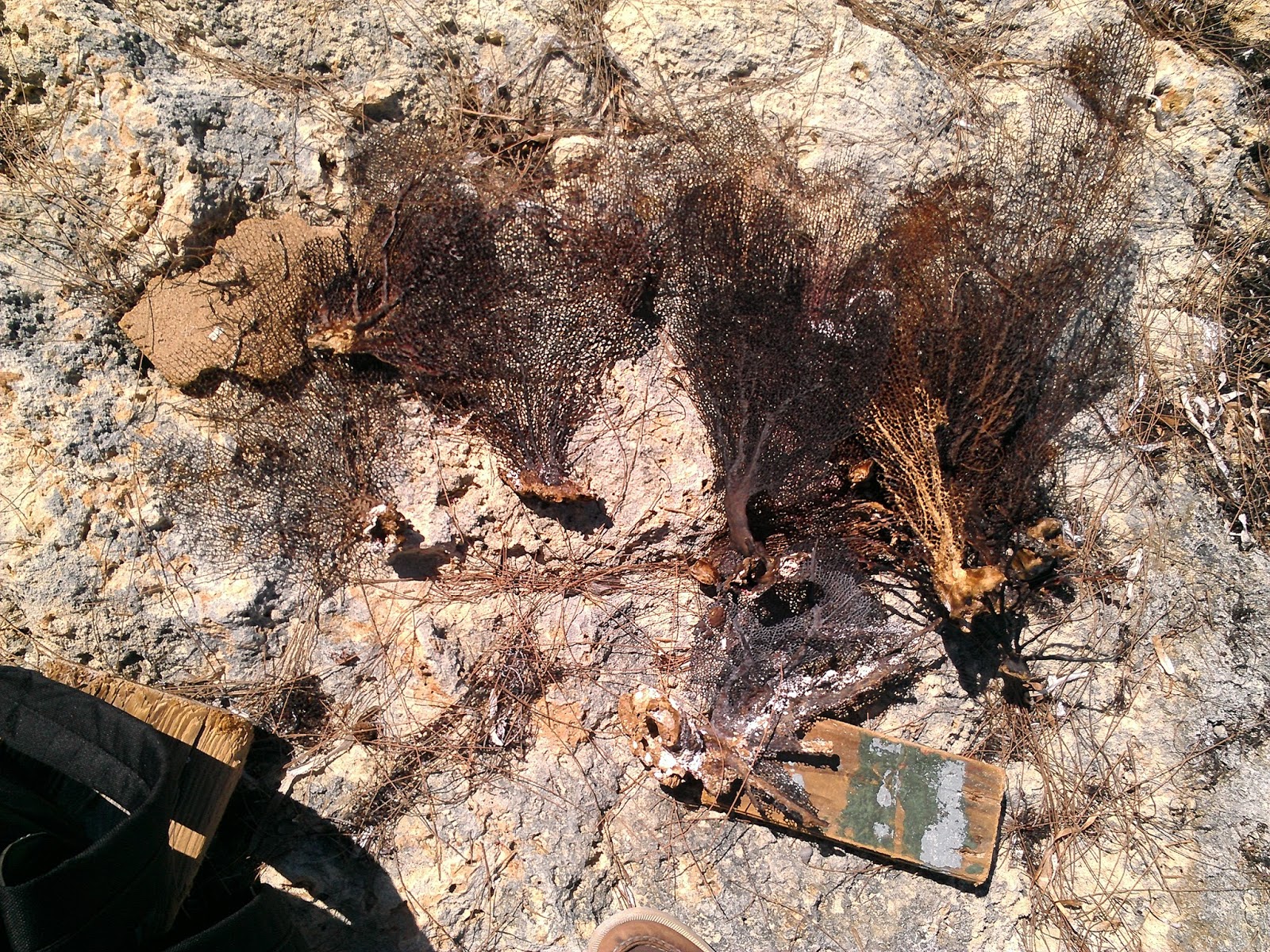
We visited other beaches on Green Turtle Cay and had picnics. We hunted for shells and sea fans. On “Ocean Beach” I found a bottle of vodka. It had been opened but was sealed with barnacles. The label had washed away but the bottle cap was metal and was imprinted with the word Vodka, in Russian, which looks more like “BO (triangle) KA”. So glad I took Russian in college! I sniffed it. It smelled like hand sanitizer. Yup, that’s vodka.

Found on Ocean Beach – I’d love to know how it got there! 
Unfortunately, no message in this bottle.
Ocean Beach
Ocean Beach
Sea Fans, collected on Ocean Beach
Limestone, dissolved by water, over time
Walking along a different, but very similar, Ocean-side beach, the next day
Nature's Art, multi colored limestone
More limestone artwork 
On Thursday, 4/9/15, we turned on the engine at 7 AM, hoisted the anchor at 7:10, and left Green Turtle Cay, headed south for ‘The Whale” and Marsh Harbor. The Whale is a set of cuts, north and south of Whale Cay. All boats, except the very smallest, need to go out into ‘the Mighty Atlantic” at Whale Cay because the interior passage is very shallow and rocky. So we go out on one end of Whale Cay, travel the 2 mile length of the island in the Atlantic, and return to the Sea of Abaco on the other side.  All travelers are concerned with the conditions at the Whale each day, since it can be very rough and occasionally impassable. Even on a calm day, sea conditions that have built up between Africa and the Bahamas can make conditions difficult in The Whale. So we listen for official reports and ask fellow cruisers (or anyone listening) for informal reports. Conditions for us were rolly and a little windy (15-16 kts), but doable. When requested, we gave this report over the radio to another boat as we were passing through.

At noon, we arrived in Marsh Harbor, the big city, ready for new adventures.

Sandy and Chuck 
on S/V Summer Wind


Friday, April 3, 2015

04-03-2015 - To the Bahamas! Crossing the Gulf Stream and Little Bahama Bank

As planned, on April 1, 2015, we woke up in the South Palm Beach Anchorage at 1:45, to leave at 2 AM. The other 4 boats, that we had talked to but not yet seen, were planning to leave at 4 AM. We’d see them on the way or catch up with them later. I had been up until about 11 the night before, finishing a blog post and talking to family.  I dropped my phone hard in the cockpit, but it seemed to still work fine. I was not well rested, but was up and excited to be going, finally.

At 2 AM, we got the engine on and the anchor up. It was still dark, but there were lights on the west side of the harbor, where a lot of industrial activity takes place. We had planned to get over to the channel on the western side of the harbor and motor up and out. No way! We grounded in the sandy bottom. Got off easily and hunted around in the dark for the exit. Didn’t find it.

Decided to cross over to the east side, even though we had avoided it earlier because we thought there was dredging going on there. The east side provided a clear exit, and of course no dredging activity was happening between 2 and 3 AM.

On our way out of the harbor, in the very dark, we suddenly spotted a small pilot boat. On it, a woman advised us to “Stay to the north and you’ll be fine.” What we didn’t realize until a few seconds later is that we were being routed around an enormous ship behind her, on its way into the harbor. This also told us that we needed to turn our AIS alarm back on! Sometimes in harbors we have to shut it off, since it alerts us constantly that we are on a course to run into another boat, because there are boats everywhere.

Once on again, the AIS started alerting us to something, but it was very dark and hard to see anything. It was the breakwater! Clear. Soon after, we heard another alert. This time it was the navigation light marking the entrance to the harbor! Clear. Once out, we saw another huge ship, to the north of us. A brief radio conversation confirmed that it was a dredge and not moving yet.

Finally we were off! The lights of the Lake Worth inlet harbor were visible for a long time. Now the moon was out and shone brightly behind us. Because it was behind, it didn’t light our course at all, but did give us a clear reference point. The seas were light, waves 1-2, maybe 3 feet at most. Very much like we had experienced so many times in New England. The winds were blowing about 14 kts, from behind, west. We put up the sails and kept the motor on.

We like to sail with the motor running for many reasons. It increases our speed. It keeps our batteries charged, which allows us to run our electronics (chart plotter, auto pilot and other instruments). It allows us to run the inverter so that we can heat food in the microwave, and charge phones and other devices without draining the battery.

We also like to motor with the sails up. Sails stabilize the boat and make the ride much smoother. And with an interior laden down with canned goods, fresh fruit and other supplies, it’s best not to toss around. The sails also make us more visible. Since one concern in crossing the Gulf Stream is shipping traffic, we wanted to be as visible as possible. They would see us on their instruments first, but actually spotting us (and not hitting us) is also important.

We are motor sailors, or, as some have said “A sail assisted power boat.”

We kept the main sail up, but soon gave up on the jib. With the wind directly behind us, the jib just wasn’t helping. Early in the trip we had great moonlight, but after a few hours the moon disappeared behind clouds. We continued motor sailing in the dark for hours. Beginning about 5 AM, we tried to hail our partner boats on the radio every ½ hour, but didn’t get a response. Too far, out of range. Around 5:30 AM, we saw and heard two small fishing boats communicating with each other. Almost no other boats or ships. No cruisers.

Our depth meter was registering “407 feet”. We later realized it “sticks” on the last number it was able to measure. I’m not sure what its limit is, but the depth in the Gulf Stream, on our path, is as deep as 719 meters, more like 2,373 feet (about ½ mile!). (So as some would say, we were never more than a ½ mile from land!)

At 6:30 AM, we were 28 miles from FL, the half way point!  Later I realized that was only half way to Memory Rock, which is just a rock, marking the western edge, or the beginning of the Little Bahama Bank. Sadly, that was still far from our destination.

We didn’t know what time to expect sunrise, but eventually it began, while we were in the Gulf Stream. 
4202 – 4/1/15, 6:54 AM, Sunrise begins
Here are a few other views from our crossing, once it was light enough to take pictures.

4204 – 4/1/15, 7:10 AM, Pretty clouds, small waves. 
4208 – 4/1/15, 7:17 AM, sunrise still in progress
4209 - 4/1/15, 7:19 AM – Sun still working hard to shine, through the clouds.
4210 - 4/1/15, 7:20 AM   - waves abeam of us.
4212 – 4/1/15, 7:21 AM  – “Red sky in the morning, Sailor take warning…”
4219 – 4/1/15, 7:28 AM – … Sailor take warning …  of dark clouds ahead?
4222 – 4/1/15, 7:31 AM, view abeam (= on the side of us)
4224 – 4/1/15, 9:55 AM – Very tired, Captain Chuck hoisting the Q Flag.
This is the Quarantine flag, required to be flown when entering a country, before checking in.

By 11 AM, we reached Memory Rock, at the western edge of Little Bahama Bank. NOT the end of the trip!

4227 – 4/1/15, 11:50 AM – On the Little Bahama Bank,
we delighted in the light aqua color of the water!
4228 - 4/1/15, 11:56 AM – We were so proud of our Q Flag!
We were actually about to check in to another country, for the first time, in our little boat!!!
4230 – 4/1/15, 12:50 PM, The captain is a little tired!
Good thing we have "Otto" (the Autopilot), our 3rd, and most reliable crew member, to run the boat.
4232 – 4/1/15, 4:11 PM – Bypassing the first possible anchorage, at Mangrove Cay. 
(“Cay” is pronounced “key.”)
I wanted to cry when we passed this  anchorage, I was so tired!
 But it didn’t offer a lot of protection from the wind, so...
4233 – 4/1/15, 7:23 PM – … So we pressed on…
4234 - 4/1/15, 7:30 PM  – ..And on.
We continued to Great Sale Cay, where we arrived just before dark. There were many boats in the protected crescent shaped bay. Chuck went for a swim. NO cell service + NO internet = No weather info.

4235 - 4/2/15, 6:49 AM – Great Sale Cay anchorage
and surrounding area was stunningly beautiful in the calm morning.
4236 – 4/2/15, 6:49 AM – view of the exit from Great Sale Cay,
so other-worldly beautiful. It was almost like we were on another planet.
4237 – 4/2/15, 6:50 AM – Great Sale Cay is a small, uninhabited island.
4238 - 4/2/15, 6:50 AM, Other boats in the anchorage in the early morning,
with clouds reflecting on the water.
4239 - 4/2/15, 6:50 AM, the clear water is so inviting!
We both swam in the morning.
4242 - 4/2/15, 6:51 AM Sunrise in the east, in the Great Sale Cay anchorage
4244, 4/2/15, 6:52 AM – sailboats leaving the anchorage, toward the west
4246, 4/2/15, 6:53 AM, Our Q Flag against the blue morning sky
4250 - 4/2/15, 7:46 AM – more boats ghosting out of the anchorage
4254 – 4/2/15, 9:53 AM - Swinging by “Jessie Ann” from Stuart FL
before leaving, to say goodbye and thank them for info.
Earlier I swam over to this boat to ask for any weather info.
Forecast was “just like this” for the next few days. Perfect!
4260 – 4/2/15, 12:22 PM – In transit toward Green Turtle Cay.
Notice my shadow on the bottom, through the clear water, as I took this photo.
During the day's journey, we saw flying fish, dolphins, and a “fish mud.” This is an area of cloudy water, which appears to be shallow (sandy) water, but instead is deep. It is thought that the sand is stirred up by fish, causing a temporary muddy appearance.

4281 – 4/2/15, 4:03 PM, passing “Center of the World Rock,” a landmark.
4284, 4/2/15, 5:59 PM, we shared Crab Cay anchorage with only two other sailboats
4285, 4/2/15, 6:00 PM, Crab Cay, with our second neighbor boat
4286, 4/2/15, 6:00 PM, looking back at Crab Cay entrance
4288 - 4/3/15 - 6:43 AM, we also swam in the beautiful clear water at Crab Cay. 
The white spots are sand, among the grasses growing on the bottom, about 10 feet below.
4289 - 4/3/15, 6:43 AM, Leaving Crab Cay anchorage in the morning
4290, 4/3/15, 6:43 AM, Leaving Crab Cay, another calm day with only ripples on the water

4307 - 4/3/15, 10:04 AM, a cell tower, mocking us!!  We still had no connectivity. Something was wrong!

4309 - 4/3/15, 11:09 AM, We later learned these were brush fires, on Little Abaco Island.
The air smelled of smoke for about 2 weeks.
4317, 4/3/15, 1:03 PM, Approaching Green Turtle Cay
4320, 4/3/15, 1:07 PM, near the entrance to White Sound, Green Turtle Cay
4330, 4/3/15, 1:40 PM, in White Sound, Green Turtle Cay, with the Bolo water taxi.
We anchored in White Sound.
4331 - 4/3/15, 2:51 PM, the first Bahamian I met, after 3 days in the country.
When I asked him if he was Bahamian, he said "Yes, Ma'am."
All Bahamians, including the children, are extremely polite.
The children all said "Good Night Ma'am" as I walked by in the evening.
4332 - 4/3/15, 2:52 PM, on the way to Customs, on Green Turtle Cay.
Can you tell from the "STOP
" that they drive on the left?
4333, 4/3/15, 2:52 PM, on the way to customs, passing the “Down Through Liquor Store”
(yellow building on the right)
4335, 4/3/15, 3:00 PM, Meeting with the Customs officer at Green Turtle Cay.
We weren’t sure if we’d be able to check in on Good Friday,
but it turns out Customs is open every day, even holidays.
4337 – 4/3/15 – Customs office, Post Office, Public Restrooms, and a Phone Booth
4336 - 4/3/15, 3:48 – lining up our plans for the weekend
4340 - 4/3/15, 3:49 PM – Heading back to the “Down Through Liquor Store”
one of many places to purchase cell phone minutes.

The “kiosk” reminded me of college. Back in the days before electronic communications, this was the only way to learn what was happening on campus! 

4341 – 4/3/15, 3:49 PM - Another notice for the Grill Out, scheduled for the next day.
(Yes, we went. The food was terrific!)
4242 – 4/3/15, 3:59 – At the Down Through Liquor Store, she is the liquor storekeeper,
bar tender, and seller of phone minutes.
Another cruising couple had given me a Bahamas Phone in Vero Beach, upon their return from the Bahamas. It had a little time left on it but not enough to make a call to the US. I had no idea how to add minutes to the phone. Turns out it’s easy, just go to the liquor store!

I wanted desperately to call my mother to let her know I was OK, because I had promised to call when I got to the Bahamas. When I made the promise, I expected to call later in the day on 4/1/15. Little did I know that it would take another 2 days before I could even try. I was very concerned that my mother would be worried about us. When I finally reached her, I discovered that she wasn’t worried at all. Maybe she didn’t realize that we were sailing in the Atlantic Ocean, across the Gulf Stream. Or maybe she forgot that I said I’d call. Oh well! She was still happy to hear from us.

4343 - 4/3/15, 4:17 PM – our last stop was at MacIntosh Restaurant
to buy Coconut Bread and Rum Cake. Yummy!

4361, 4/3/15, 5:19 PM – Hoisting the Bahamas Flag, at long last!
Sandy & Chuck
on s/v Summer Wind

Double click on photos to see a larger view.

Do you have the address of our blog? It's http://cruisingwithsummerwind.blogspot.com/

Now you can sign up to receive email when a new post is loaded. See the column on the right.

Note that I'm backfilling with pieces that I didn't get to write while we were living them. So please keep reviewing the contents list to make sure you've seen everything. I change the "posted" dates so posts remain in chronological order.